Coyote and Squirrel Trails

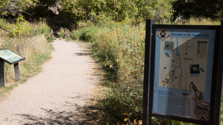
Coyote and Squirrel TRAILS In Rifle Falls State Park, the Coyote Trail winds past limestone caves, through a lush riparian and forested area, then climbs to a birds-eye view of Rifle Falls. Kids of all ages will love exploring the caves. Bring a flashlight for the largest one. Squirrel Trail crosses East Rifle Creek and winds through Gambel oak forest…

Read more

Cliff Lakes Trail

Cliff Lakes Trail This trail provides access to THE Cliff Lakes and South Fork Campground Cliff Lakes Trailhead is located off Forest Road 601. Four-wheel drive vehicles are highly recommended. From Rifle, head east on I-70 for 15 miles. At the New Castle exit (105), turn left at the ramp and follow the signs into New Castle. At 7th Street…

Read more

Bobcat Trail

Bobcat TrAIL The trail hikes along East Rifle Creek through boxelder and cottonwood forests, and into open grassy meadows. This is a newly completed trail that links Rifle Falls State Park and Rifle Falls State Fish Hatchery. It provides access to secluded fishing spots on the creek bank, as well as passing several well stocked trout ponds managed by the fish…

Read more

Beaver Creek Trail

Beaver Creek Trail Beaver Creek Trailhead #2161 is one of the closest Forest Service recreation sites to Rifle, located just 9.5 miles from the roundabout just south of I-70.  It’s a great hike all four season of the year, however, you’ll need snowshoes in the winter months. The trailhead is located 9.4 miles from the roundabout just south of the I-70 overpass.…

Read more

Battlement Trail (Parachute Trailhead)

BATTLEMENT TRAIL(PARACHUTE TRAILHEAD) Battlement trailhead provides access to a 4-wheel drive jeep trail and a hiking/horseback trail to the Battlement Reservoirs. The Battlement Reservoirs are a chain of seven lakes located in a pristine high mountain setting, south of Parachute Colorado. From Rifle, head west on I-70 to Parachute (15 miles) and take exit 75. Turn left and follow County…

Read more

West Rifle Creek State Wildlife Area

West Rifle Creek State Wildlife Area perfect for hunting, hiking and wildlife viewing. West Rifle Creek State Wildlife Area is approximately 1243 acres (1.94 sq. miles or 5.03 sq. kilometers) and ranges from 5,959 ft to 6,835 ft in elevation. The drive along Country Road 252 through this area is a lovely trip into an unspoiled part of the Old…

Read more

Dry Rifle Creek Area

Dry Rifle Creek Area Located between Grass Valley Road and the Grand Hogback, the Dry Rifle Creek Area is great pinyon and juniper hill country A dry offshoot of Rifle Creek separates the area from the main road, but it can be crossed with most vehicles. The area is criss-crossed with both motorized and non-motorized trails and its popular for…

Read more

Cedar Mountain Area

Cedar Mountain Area Cedar Mountain rises north out of Rifle Gap The area begins at lake level as high desert pinyon-juniper forest. At its top, it features aspen and evergreen forests at 8,200 feet. ATV and 4WD trails criss-cross the area and it is heavily used for hunting in the fall. From the adventurer’s perspective, it is an interesting area…

Read more

West Elk Trailhead & Parking Area

Buford Road Parking Area and Trailhead the West Elk Trailhead, is a popular jumping off point for summer and winter outdoor activities in the Flat Tops From the parking area you can access miles of multi-use trails and roads, including the Cherry Creek Trail and Mansfield Ditch for mountain biking and hiking and a maintained cross-country ski area in the…

Read more

Blair Mountain Trail

Blair Mountain ROAD & Trails Blair Mountain is the highest point of the western Flat Tops with an elevation of 11,400 feet. A hike to the top gives amazing views of the entire Flat Tops. The terrain consists of a high plateau covered in alpine grasslands with occasional stands of spruce or fir.  The west side of Blair Mountain is…

Read more