Search
Close this search box.

Rifle Riparian Zone

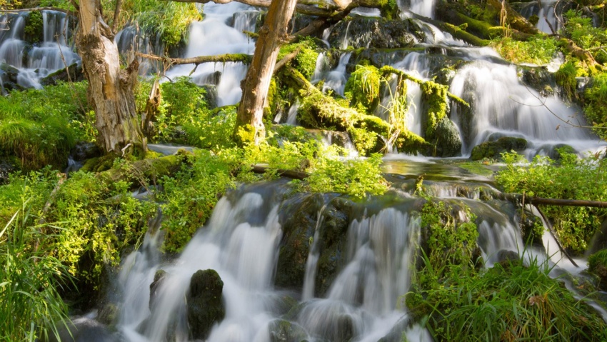
Rifle Riparian Zone https://vimeo.com/500254395%20 The Riparian Zone is located just south of the fish hatchery and features hiking trails, a series of small cascading falls, and beautiful fishing ponds, all along Rifle Creek. Rifle Creek is loaded with trout in this area and wildlife viewing opportunities abound. The hiking trails connect the Rifle Fish Hatchery on the north side of…

Read more

Rifle Gap Dam

Rifle GAP DAM Rifle Gap Dam is about 5 1/2 miles north of Rifle, at a point where Rifle Creek cuts through the Grand Hogback. The dam was built between 1964 and 1967 by the United States Bureau of Reclamation for irrigation water storage. The dam is operated by the Silt Water Conservancy District and creates Rifle Gap Reservoir. The…

Read more

Cow Creek Road

Cow Creek road Cow Creek Road offers an easier, albeit Longer alternate ROute to the JQS Trail for accessing the top of the Roan Plateau. This Cow Creek Road can be accessed by taking Highway 13 North out of Rifle for 18 miles, then taking the Piceance Creek Road (County Road 5) West toward Rangely for 4.5 miles.  The Cow Creek…

Read more

JQS Road

JQS Road 4×4 Recommended The JQS Road is a 7-mile dirt road adventure climbing 3,000 feet up the side of the Bookcliffs to the top of the Roan Plateau. The route is great for OHVs, mountain bikes, and vehicles with 4-wheel drive and high clearance who are willing to brave the extremely narrow, steep, rocky, and potentially treacherous conditions. Near…

Read more

The Flat Tops

THE Flat Tops The region is a high plateau filled with forests, meadows, hills, canyons, valleys, and spectacular views of DISTANT mountain ranges. The name Flat Tops refers to a large region of the White River National Forest northeast of Rifle.  Contrary to their name, the western Flat Tops nearest Rifle are not actually flat. More accessible than its wilderness…

Read more

Rifle Creek Valley

Rifle Creek Valley Follow Rifle Creek as it spills out of the Flat Tops and into the ranchlands and communities below. This trip highlights the best of Rifle. And bring your toys! With three State Parks (Rifle Falls, Rifle Gap, and Harvey Gap) Rifle Mountain Park, Rifle Creek Golf Course, and endless BLM and Forest Service lands, you can spend…

Read more

Hubbard Mesa Recreation Area

Hubbard Mesa Hubbard Mesa is a 2,480-acre colorful desert landscape of mesas and rock hoodoos at the base of the Roan Plateau. Visitors are greeted with 50 miles of single track, ATV, and jeep trails. This means that when it comes to recreation, if you can dream it you can (mostly) do it. Just be safe out there adventurers! Hubbard…

Read more

Rifle Creek Golf Course

Rifle Creek Golf Course The golf course is a public 18 hole championship golf course designed by Richard M. Phelps. Rifle Creek Golf Course is located at 3004 Highway 325, just north of Rifle, Colorado. Golfers will enjoy playing the challenging course with distinctively different nine hole courses, while simultaneously reveling in the scenic beauty of the Rifle Creek Valley.…

Read more

Harvey Gap Reservoir State Park

Harvey Gap State Park Swimming and Picnic Area A GREAT WAY TO BEAT THE SUMMER HEAT Harvey Gap is a 198 acre reservoir featuring great opportunities for fishing, swimming, and stand-up-paddleboarding.  Motorized boats are allowed with a 20 HP maximum and there is a boat ramp on the east side of the lake. Anglers catch catfish, largemouth and smallmouth bass,…

Read more

Lakota Canyon Ranch & Golf Club

Lakota Canyon Ranch & Golf Club Featuring stunning views of rugged Western Colorado canyons and natural terrain, come enjoy the scenic Colorado golf at Lakota Canyon Ranch & Golf Club. Lakota Canyon Ranch opened for play in May 2004, offering a world-class 18-hole championship golf course designed by James Engh. View Real Western Adventure Map View Rifle Creek Valley Area

Read more